
East Pacific Offshore Zone Forecasts
Christopher Landsea, NOAA’s chief of tropical analysis and forecast, writes: “I’m proud to announce that our East Pacific Offshore Zone forecasts of winds/waves/warnings are now official and freely available 24 hours a day/365 days a year.”
Find the new forecasts at https://www.nhc.noaa.gov/marine/offshores_eastpac.php. “These five-day forecasts are an important new service enhancement in hurricane-prone areas to help keep blue water mariners safe,” added Landsea (great name).
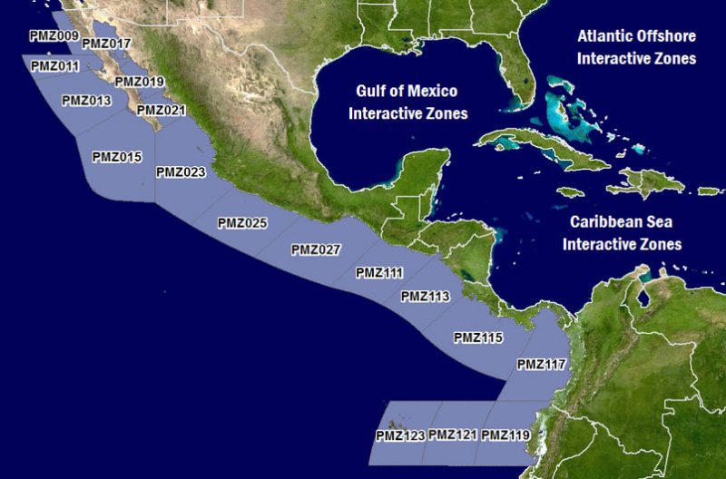
The Eastern Pacific is vulnerable to tropical storms and hurricanes. Hazardous marine weather in the region affects recreational sailors, fishing boats and commercial ships — including traffic heading into and out of the Panama Canal. According to NOAA’s National Hurricane Center, “These new Offshore Zone forecasts represent a dramatic increase in predicted lead-time and detail. Only broad-brush two-day text forecasts were available previously for this part of the Pacific Ocean. Such improvements should, hopefully, promote better decision-making by captains and crew in hurricane-prone waters.”
Ten marine zones cover an area within 250 miles of Mexico, Central America and Colombia, and within 750 miles of Ecuador to include the Galapagos Islands, a waypoint popular with Pacific Puddle Jump sailors. Forecasts include 10-meter winds, significant wave heights, primary swell direction, dominant wave period and significant weather. NOAA offers the information in text and interactive-map formats.
The Eastern North Pacific hurricane season runs from May 15 through November 30.
Great News! Thanks. The forecast could be improved by dividing into smaller segments the zone called “Entrance to the Sea of Cortez, including Cabo Corrientes” Cabo Corrientes deeserves its own segment. As does the Southern Crossing.