| Back to Features | South Pacific Cruising Strategies |
|
Missing the pictures? See our February 2012 eBook!
We've always found it curious that most North American sailors will spend years preparing for a dream trip to the South Pacific, but once they finally get started they'll race all the way to New Zealand or Australia in a single season.
From the West Coast to Australia is an enormous distance — almost 8,000 miles — and it's also a paradise for those who enjoy warm weather, clear water, varied cultures, and great safe cruising. With those things in mind, we knew we didn't want to rush through. So by the time my wife Sherry and I passed through the Panama Canal aboard our CSY 44 Soggy Paws in September of '08, we'd done lots of research and planning, which has served us well ever since. We intend to spend five or more years in the Pacific.
There are at least four popular route options for cruising boats crossing to French Polynesia from the Americas. Each has advantages and disadvantages, and each requires different timing. Here are those that we considered:
- Take the most well-traveled route directly to the Marquesas from any Pacific port in the U.S. or Central America.
- Sail to the Galapagos, on the equator, then take the direct route to the Marquesas.
- After the Galapagos, sail south to Easter Island, and perhaps Pitcairn Island, entering French Polynesia via the Gambier Islands. Then sail north to the Tuamotus and Marquesas.
- Sail south to visit Peru and/or Chile. Then, the following season, leave from any of the South American ports directly to Easter Island and continue on as in option 3 above.
The South Pacific Milk Run
By far the most commonly traveled route is the first leg of the so-called Pacific Milk Run to the Marquesas. It's roughly 3,000 miles, depending on where you start from, and is typically mostly a broad reach or downwind. The best time for crossing on this route is March-April, so you arrive in the Marquesas near the end of the southern cyclone season. For most, this route will cross the equator and the Inter Tropical Convergence Zone (ITCZ), where many boats experience calm or unsettled weather.
Once south of the ITCZ, the sail will be in mostly E-SE trade winds. Of course it's important to note that there are no possible stops along the way to break up the trip. Once in French Polynesia, three island groups are normally visited: the Marquesas, the Tuamotus and finally the Societies (Tahiti and her sister islands).
Via The Galapagos
A crossing to the Marquesas from the Galapagos, which lie about 500 miles west of Ecuador right on the equator, is also about 3,000 miles. However, you will cross the ITCZ between Panama and the Galapagos before heading west.
If you want to spend some time in those unique islands — which inspired Darwin's theory of evolution — be sure to check out the current immigration regulations before leaving the mainland. (See our website below for a description of our stay in the Galapagos from January to March 2010.)
Departure timing and the rest of the Milk Run comments in option 1 above apply here also. In addition to the obvious advantage of seeing the unique animal life of the Galapagos, stopping there potentially allows for repair work, crew changes, and re-provisioning.
Via Easter Island & Pitcairn
The sail from the Galapagos south to Easter Island (27°S 109°W) is about 2,000 miles and mostly a beam reach. Because this trip takes you well south of the trade wind belt, it should be done earlier than the Milk Run in order to take advantage of the more settled weather during the southern summer. Our reseach indicates that January and February are good months to leave the Galapagos for this trip.
Once at Easter Island, it is about 1,100 miles to Pitcairn Island (famous as the hideaway of the HMS Bounty mutineers), then another 300 miles to the Gambiers. All three stops offer unique experiences. By the time you reach the Tuamotus, in April, cyclone season will be nearly over. If you have planned ahead and obtained a Long Stay Visa for French Polynesia, you'll be able to take your time seeing French Polynesia, with many cruising options. With our Long Stay Visa we were able to spend our full six months in the Gambiers, Tuamotus and Marquesas. By doing this eastern part of French Polynesia backward from the normal Milk Run route, we avoided the crowded anchorages. This route also positioned us for an easy sail to Hawaii in late September/early October for the upcoming southern cyclone season. (More on this later.)
Via Peru and/or Chile
For those who sail down to Peru or Chile first, it makes sense to leave from any port in western South America and sail directly to Easter Island. If leaving from Chile, the normal route is to stop in the Juan Fernandez Islands, 600 miles out (where Scottish sailor Alexander Selkirk was marooned in the early 1700s, apparently inspiring Daniel Defoe's novel Robinson Crusoe).
This area normally has southeast trades, so it will be a broad reach or downwind run. From Lima, Peru, the distance is only about 2,000 miles, but this route sometimes crosses the high pressure area that sits north and east of Easter Island, and you might find lighter winds.
Once south of about 22°S, you are no longer in the trade winds. The most settled weather is in the southern summer, January to March, so that is the best time to make this trip. The remaining comments in option 3 above apply.
Wintering in Hawaii
Even with a six-month Long Stay Visa we felt somewhat rushed to visit the Gambiers, Tuamotus and Marquesas, especially with the superb scuba diving we found in the Tuamotus. So we delayed our progress west by “wintering over” in Hawaii during the southern cyclone season.
From the Marquesas, the last island group we visited, it is an easy 2,000-mile, mostly beam or broad reach, northwest to Hawaii. We had a near-perfect passage with 12-15 knots of wind and light seas all the way, and an easy ITCZ crossing (late September and early October). Of the 500 boats that crossed the Pacific in 2010, we know of about ten that chose to go to Hawaii for the winter. About half of those left from the Marquesas and half from the Societies. The farther east you can get for your departure north, the easier the trip will be due to the wind angle advantage.
On the return to French Polynesia we left at the end of April from Oahu and had a somewhat rough, windy passage for the first week, close-hauled, with winds in the 18- to 22-knot range. After that it settled down and we had a pleasant passage through the ITCZ and during the last two weeks. As with any long passage, timing and good weather information is essential. And it helps to have someone watching the ITCZ for you too.
The Second Year
We arrived in the Western Tuamotus in mid-May. Then, after a month or so, worked our way southwest with the rest of the Milk Runners to Tahiti for the annual Puddle Jump crossing celebration called the Tahiti-Moorea Sailing Rendezvous. Its activities are very worthwhile as an introduction to South Pacific culture.
Afterwards we still had four months to get to Tonga before the start of the southern cyclone season. So we meandered behind the crowds through the Societies, Cooks, Samoas and on to Tonga. We arrived just as the rest of the cruisers were leaving for the 1,200-mile crossing south to New Zealand. This can be a dangerous crossing, which must be done again coming north the next year.
For us, the next few weeks involved securing our boat for the two months we would be on vacation back in the U.S. November and December are officially at the start of the southern cyclone season, but because Tonga rarely experiences cyclones then, it was a good time for us to be away from the boat. We used a strong mooring maintained by some former cruisers at Tapana (The Moorings' anchorage 11 on the charts), south of the main harbor at Neiafu, Vava'u. There are also a number of strong moorings available right inside Neiafu harbor.
There are many reasons for taking more than one season to see French Polynesia. Not all are obvious until you've been here for a while and have talked to some of the many international cruisers who have spent multiple years here and in the western Pacific. At present, very few Americans spend more than three months in French Polynesia and only a few take more than six months to cross the Pacific to New Zealand or Australia during their first year. After that the normal Milk Run brings cruisers from New Zealand back north to Fiji or Tonga, then all the way to Australia at the end of their second southern cruising season.
The major reasons most cruisers don't take longer are cyclone seasons and immigration issues. But in some cases it is just poor prior planning. For others it is the rush to get west for one reason or another. And then there are those that just want to stay with their Milk Run buddies.
Wintering Over
Options for avoiding the southern storm season and delaying your progress farther west include: staying in any place within 8° of the equator or anywhere north of it, hauling out at a cyclone-protected boatyard, and tying to a strong mooring in a protected storm anchorage.
Cyclone season cruising destinations across the Pacific include such places as Hawaii, the Line Islands, Kiribati Islands, the Gilberts, the Marshalls, Micronesia, New Zealand, the Solomons, and Papua New Guinea. In French Polynesia there are a number of good places to haul out (some where they will bury your keel in the sand), including Apataki in the Tuamotus, and Tahiti and Raiatea in the Societies. Farther west, both Tonga (Vava’u) and Fiji (Savusavu/Buda Point) have strong storm moorings in well-protected hurricane holes.
The Western Pacific
From French Polynesia westward to Australia the distances between stops are much shorter, and there are many options for things to see and do. You'll find island groups on both sides of the equator, and thus the opportunity exists to cruise north and south to avoid the cyclone/typhoon seasons. Since the trade winds generally flow from the northeast north of the equator and from the southeast south of the equator, moving north and south within about 20° of the equator is relatively easy. It is only when you want to go back east that things get more difficult, although not impossible.
Here's an example of what is possible during a multiple-year Pacific cruise. We're currently in Tonga. In our third year we plan to visit Fiji during the southern winter cruising season, starting in May, then move north to the Marshalls in October to avoid the southern cyclone season.
In our fourth year we'll remain in the Marshalls over the northern winter and summer for the diving season — as you might have guessed, we love scuba diving. Once the northwestern Pacific typhoon season has died down, probably in January, we'll move west through the Federated States of Micronesia just south of 10° N to Palau. We'll remain in Palau through the northern summer and most of the following winter. In March we'll use the Northwest Monsoon to cruise southeast to New Guinea, the Solomon Islands and the relative safety of the equator. See chartlet:
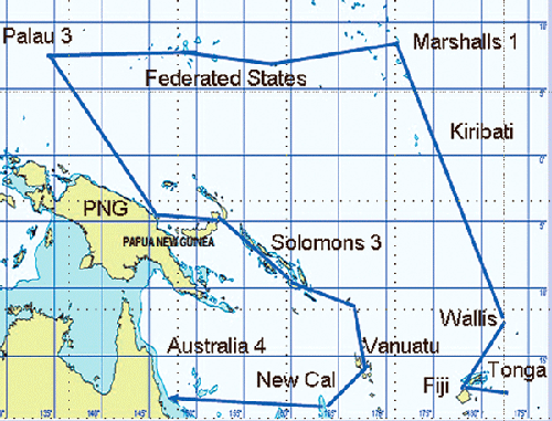
The following year in May, during the southern winter cruising season, we'll continue south, then west, through Vanuatu and New Caledonia to Australia.
Major Cruising Issues
Below are three of the more difficult issues you must deal with when deciding how to cross the eastern Pacific through French Polynesia:
- Immigration — Unless you obtained a Long Stay Visa prior to arrival, French Polynesia allows U.S. citizens to stay only 90 days in a six-month period, although the boat can stay for a year. No exceptions. (For Long Stay details see: www.pacificpuddlejump.com/longstayvisa.html)
Keep up to date on the regulations at Jimmy Cornell’s website, www.noonsite.com. EU citizens are allowed to stay in French Polynesia for two years without having to do any extra paperwork.
- Tropical Storms — Storm seasons drive timing for a safe cruise across the Pacific. Warm water and air enhance storm formation; therefore summer is storm season in both hemispheres. El Niño years allow warm water, and therefore storms, to move farther east. Cyclone season in the southwest Pacific, including most of French Polynesia, is November to May. Hurricane season along the Central American coast is June to November. Typhoon season in the western North Pacific is June to November, but there can be typhoons any month. Only the area within about 8° either side of the equator is a relatively safe zone.
- The ITCZ — The Inter Tropical Convergence Zone (ITCZ), not to be confused with the SPCZ further southwest, is an area of frequent thunderstorms and squalls of variable magnitude, within about 10° of the equator. Crossing it safely involves careful boat preparation, timing, and good access to weather resources.
We hope some of you reading this will consider planning a multiple-year visit to the South and Western Pacific. We think you'll find this vast and beautiful area to be one of the highlights of any 'round-the-world voyage.
| South Pacific Resources
There are many worthwhile resources on cruising the South Pacific. These are some favorites: |
- dave mccampbell
To study details of Dave and Sherry's cruising plans, along with chartlets, see: www.svsoggypaws.com.
![]()
This story was reprinted from the the February 2012 issue of Latitude 38. To order a copy (complete with color photos), use the subscription order form, and specify the 2/12 issue, or just drop us a note with a check for $7 to Latitude 38, Attn: Back Issues, 15 Locust Ave., Mill Valley, CA 94941.
Please note: After a few years, the actual issue may no longer be available, but we will still be able to make photocopies or PDFs of it.
You can also see this issue on eBook through our eBooks page.
Calendar | Letters | Changes in Latitudes | Features
Classy Classifieds | Place a Classy Ad | Advertisers' Links | Display Advertising
Links | New Stuff | Subscriptions | Distribution | Contact Us | Home
© 2014 Latitude 38 Publishing, LLC. All rights reserved.